The timeline, split at grade.
Permits issued each month sit above the grade line, and the filings, demolitions and land sales before the permit sit below it.
Drag across the months to set the period for everything on the map.

A permit and pre-permit map for Florida general contractors, built on official public records only.
It moves like Google Maps: scroll and zoom from the whole state down to a single parcel.
At state scale, it shows Census new-home permit counts by county.
Filings, land sales and demolitions come before a permit, and each one is staked on the map in survey orange.
Pick a project, and its card tells the public life of that piece of land, from the land sale and the planning filings to the permit.
A grade line marks where ground breaks.
General contractors ranked by permitted value: the valuation on issued building permits for new construction, additions and alterations.
Pick one, and their permits light up on the map.
Pick a trade and see the subs who’ve pulled permits on similar work nearby, with their license status from the state’s DBPR files.
A license it can’t match is never called unlicensed.
Before a call, I type in your company name or license number, and your public permits in the areas it covers light up.
In Who’s building, your company shows as “You.”
Want to see your own permits on it?I’ll plug your company in before the call.
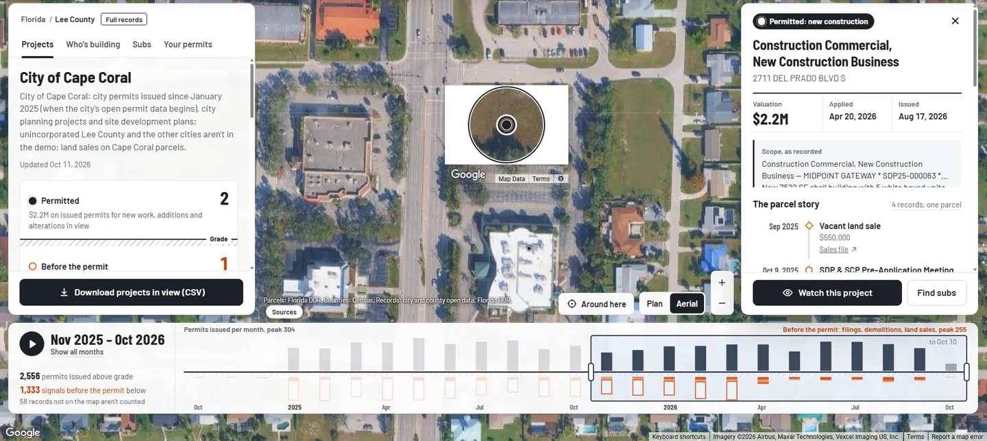
Permits issued each month sit above the grade line, and the filings, demolitions and land sales before the permit sit below it.
Drag across the months to set the period for everything on the map.

For each area with permits, it shows the median months from a parcel’s first filing, land sale or demolition to its first issued permit for new construction.

Each card shows the address and the scope as the source recorded them, and every public record on the parcel, each linked to its official source.
When the permit hasn’t been issued yet, the story says it’s at the permit desk.

Pick a project, and a circle opens through the map to the aerial view of the real ground, with the parcel line drawn in white.

A one-mile lens at the center of the map lists only what’s inside it, and it moves with the map.

Search finds counties, project names, permit numbers, parcel addresses and companies in the data.
Every permit, filing, land sale and license on the map traces to an official public record, with the source one tap away.
Florida has no single permit feed, so I connect counties one at a time.
It doesn’t show owner names, and individual applicants’ names are dropped.
Axis Groundbreak is a permit and pre-permit map for Florida general contractors.
It shows the filings, land sales and demolitions that come before a permit, who pulled each permit, and the subs who have done that kind of work nearby, with their license status.
Official public records only: the cities and counties, the state’s license files, the property tax roll and the Census.
Every card links to its official source.
Permits and planning records for the City of Orlando, Miami-Dade County and the City of Miami, and Cape Coral, and planning records only for Hillsborough County, Pinellas County and Clearwater.
Florida has no single permit feed, so I connect counties one at a time.
No. It doesn’t show owner names, and that’s on purpose.
It shows each sub’s license status from the state’s DBPR files, and how the license was matched.
A license it can’t match is never called unlicensed.
No. It puts Florida’s early public records (land sales, planning filings and demolitions) on one timeline per lot, each one linked to the official record, and shows where you rank.
Every area shows the date its records were last updated.
On a screen share.
Before the call, I type in your company name or license number, so any public permits you have in the areas it covers are already lit up.
Book a time, and I’ll plug your company in before the call starts.
For your website: .